How to Read ICAO NOTAMs

The FAA has announced that during the Spring of 2026, they are going to switch NOTAMs from the domestic format to ICAO (International Civil Aviation Organization) .
ICAO NOTAMs are separated into "series", which each series or lines contain categorical information on the NOTAM. This can allow an user to easily filter categories depending on severity and types of NOTAMs.
Compared to a domestic NOTAM, where all information is displayed in a single line, an ICAO format will allow anybody to quickly grab key information from the NOTAM.
Below is a sample of a domestic and ICAO format NOTAM D:
ICAO
B0667/21 NOTAMN
Q) KZAU/QMRLC/IV/NBO/A/000/999/4159N08754W005 <QUALIFER>
A) KORD <LOCATION>
B) 2106231700 <FROM>
C) 2106232300 <TO>
D) <SCHEDULE>
E) RWY 04L/22R CLSD <MAIN MESSAGE>
F) <LOWER ALTITUDE LIMIT>
G) <UPPER ALTITUDE LIMIT>
Domestic
!ORD 06/001 ORD RWY 04L/22R CLSD 2106231700-2106232300
As you can see, the ICAO format is more organised, however, contains a lot more information. However, when domestic NOTAMs gets long and complicated, the ICAO format will be easier to discern key information.
How To Read ICAO Format
The first line indicates the series of the NOTAM. The first letter of the NOTAM will identify the category of the NOTAM called series.
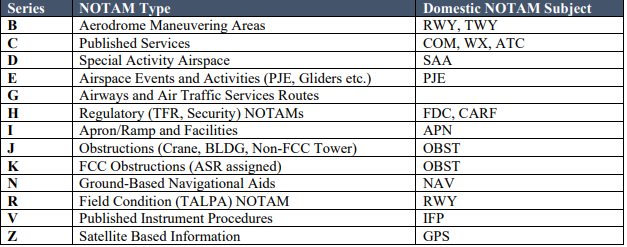
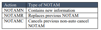
Series and Action tables provided below.
B0667/21 NOTAMN
| B | Series Aerodrome Maneuvering Areas |
| 0667 | ID |
| 21 | Day of the month |
| NOTAMN | Action NOTAM contains NEW information |
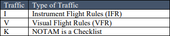
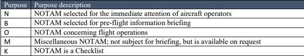
Q) KZAU/QMRLC/IV/NBO/A/000/999/4159N08754W005 <QUALIFER>
The Q line, also known as the qualifier line, will give a summary in category form in regard to the NOTAM.
Traffic, Purpose, and Scope label tables provided below.
| KZAU | Flight Information Regions (ie. ARTCC) |
| QMRLC | NOTAM Code |
| IV | Traffic Codes: traffic that will be affected by this NOTAM I: Instrument Flight Rules V: Visual Flight Rules |
| NBO | Purpose: intention for this, who does it affect N: Immediate attention B: pre-flight briefing O: Concerns flight operations |
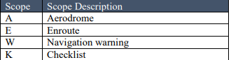
| A | Scope: location A: Aerodrome |
| 000 | Lower limit in Altitude (000 = Default value for limit if none given) |
| 999 | Upper limit in Altitude (999 = Default value for limit if none given) |
| 4159N0875W005 | Coordinates and Radius 4159 North 0875 West 5 NM of radius |
A) KORD <LOCATION>
| KORD | Chicago O'Hare International Airport |
B) 2106231700 <FROM>
| 2106231700 | 2021, June, 23rd, 1700 Zulu - initial valid time |
C) 2106232300 <TO>
| 2106232300 | 2021, June, 23rd, 2300 Zulu - end valid time |
E) RWY 04L/22R CLSD <MAIN MESSAGE>
| RWY 04L/22R CLSD | Runway 04L and Runway 22R are closed |
Tables for Series and Qualifier Line
Series
Action
Traffic
Purpose
Scope
To learn more about the transition, read this notice provided by the FAA.
You should also read:

How to Read All METAR Remarks
Remarks are at the end of a METAR that will explain further details about the current weather at the designated location. They can add further details about tornadoes, winds, visibility, temperature, pressure, etc. Read and understand about METARs before diving into the Remarks. Below is…
Continue reading...
How to Read a FICON NOTAM
A FICON (Field Condition) NOTAM (Notice to Airmen) reports runway, taxiway, and apron conditions which includes ice, snow, rain, etc to inform pilots of breaking action. Look up your local aiport's FICON NOTAM using the FAA NOTAM Dashboard. FICON NOTAMs are used to describe the…
Continue reading...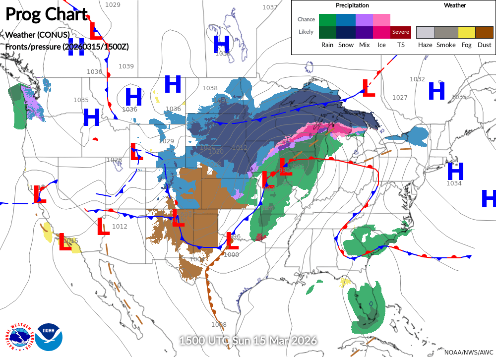
How to Read A Prog Chart
A prog chart (Surface Analysis Prog Charts) is a forecast chart created by the Weather Prediction Center that provides surface pressure systems, fronts, and precipitation for a multiday period. Each prog chart will forecast a "snapshot" of the weather at the given issued time. The…
Continue reading...